Cadiz has many paths to enjoy its cultural and natural heritage, archaeological sites, medieval fortresses, Roman roads, dunes, marshes, pine forests, flamingos and brambles. The province is very extensive and has a large number of paths to discover its corners. Put on your boots, put on your cap, don’t forget your bottle of water, and discover with us the most charming places in Cadiz.
En este post podrás leer:
Algarbes – Betijuelo
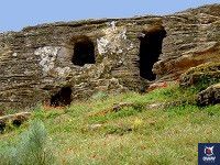
The route begins in the Natural Park of the Strait, at this point we find the archaeological site of the Algarbes. In this set we can observe multiple funerary structures in caves and megalithic covered gallery burials. Although its access is restricted, it is a good way to approach the heritage and nature.
Route: linear
Length: 5.6 kilometers
Time: 2 – 4 hours
Difficulty: medium
The archaeological complex is one of the most important in the province of Cadiz, a Bronze Age site excavated between 1967 and 1972. In the first stage we will surround the burial site, heading west. Among the vegetation, we will find trees from far away lands mixed with native species such as mastic, palm hearts and kermes oak. In our route we will find the Lomas de San Bartolomé, place chosen by the Romans to control the nearby city of Baelo Claudia, and also by the climbers since the end of the 60’s. The route ends at the Arroyo de los Puercos which is generally dry. The path leads to a wooden fence where we can admire the landscape. From here, we descend to find a track that leads us to the road where the path ends, although if time and tide allow it, we can return along the beach.

Cerro Aguila
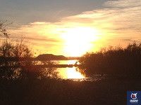
Doñana, the space full of riches, is discovered in part by this path. The beginning of the route is in the enclave of the bird observatory that characterizes the Doñana Park. The itinerary offers a tour of Mount Algaida. Among pines and bushes, there are also animal species.
Route: circular
Length: 4.7 kilometers
Time: < 2 hours
Difficulty: low
In the beginning, the artificial lagoon known as “tollo”, originated in the 80’s after an extraction of aggregates. Since then it has become the ideal refuge for many birds such as ducks and grebes. We will pass by the Monte Blanco, one of the driest areas of the stabilized sands. The path continues through the large pine trees, plantations from the beginning of the 18th century. They are exploited with the harvesting of the pineapples to extract the pine nuts, a highly valued nut. The coastal savines are also part of the landscape, a species of great ecological value that contributes to the stabilisation of the dunes. At 14 metres above sea level, we reach the end of this route in the fossil dune. From this point we can observe the panorama of the National Park.
Del Acantilado
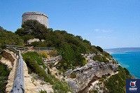
In two different directions, this route, which wanders along the edge of the Barbate Cliffs, offers impressive panoramic views. The cliff has been shaped by water, which due to its permeability, has given rise to the formation of aquifers known as caños. The real protagonists of the path are the sea and the rugged coast of Barbate.
Route: linear
Length: 6.2 kilometers
Time: 2 – 4 hours
Difficulty: low
The access to Hierbabuena beach is the starting point of this path that runs through the mobile dunes in the first section. We will find typical vegetation of the Andalusian Atlantic coast such as the barrel or the sea lily. The route hides water sceneries, retained by permeable materials that lead to wells like the one we can see in ruins at about 25 meters, and pipes that give name to some enclaves in the area. One of the main stops is at the Tagus Tower. This is a beacon tower, built in the 16th century, at the highest point of this cliff. This tower was part of a defensive system against the threat of Berber incursions.
In addition to the tower’s viewpoint, there is another viewpoint about 100 metres away where we can see the coastline to the east with towns such as Barbate or Zahara de los Atunes, lighthouses and capes such as Punta Camarinal, and opposite Africa. Interesting from this point too, are the walls of the cliff, as they draw whimsical shapes of different colors and textures. From the tower, we descend through the young pine forest of La Breña until the end of the route.
La calzada dehesa boyal
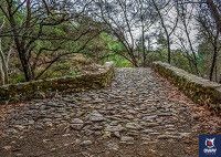
The Campo de Gibraltar, the Pueblo Nuevo de Castellar and the coast are some of the proposals offered by the path, with unbeatable views from the Los Alcornocales Natural Park. This trail is a small part of a great international trail, the GR-7, which starts in Tarifa and goes to the Greek Peloponnese.
Route: linear
Length: 5.2 kilometers
Time: 2 – 4 hours
Difficulty: medium
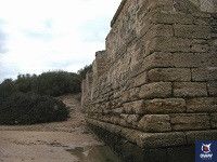
The route is part of an ancient Roman paved road that was possibly laid out on a previous path. This section of the road is one of the best preserved in the area, due to its continuous use over time. Two kilometres from the start, there is a turn-off leading to the Fuente Vieja, where you can walk to the fountain construction for 700 metres. It offers beautiful views of the Guadarranque reservoir and its surroundings. It is also the tombs that cross our path. They are cavities dug into the rock from the pre-Roman period. The easy modelling of the sandstone has favoured this type of deposit in the natural park. They used to be located in prominent and slightly inclined places, allowing the head to be higher than the feet, as a sign of domination of space.
Punta del boqueron
On the beach of El Castillo, in the heart of the Natural Park of the Bay of Cadiz, we discover the Punta del Boquerón. Through a footbridge or by its marked track, we find this route that allows us to know the symbiosis of two ecosystems, the dunes and the marshes. The Punta del Boquerón has been declared a Natural Monument, as well as the assets of cultural interest of the Urrutia battery and the Sancti Petri Castle.
Route: linear
Length: 2.6 kilometers
Time: < 2 hours
Difficulty: low
The path that is part of this route is a cattle track, the Vereda de Chiclana de la Frontera, where decades ago the region’s cattle passed.Camposoto Beach is where the trail begins, this was an exclusive military use zone until the 60s, and became part of the full disposition of citizens in the 80s. We will see how the marsh has taken over the old abandoned salt mines. An obligatory stop is the small lookout point where we can see on the left the island where a 17th century fortress is located, taking advantage of an earlier one from the 13th century. Continuing with the path, we move away from the coast to go into the dunes and thus access the Sancti Petri stream and end of the path. Here we find some ruins known as the Urrutia battery, whose architecture is abandoned and wrapped up in the undergrowth. The battery was in charge of the defense of this important strategic point. It was built in the 18th century to defend San Fernando from the sea. In front of us, Sancti Petri, an old almadrabero town, with its small port. From the port you can see the Canal del Molino and the Canal de los Carboneros. And all along the channel it is very easy to observe animals such as flamingos or herons.
Also you can check our best Tours in Cadiz on the next links:
White Villages of Cadiz Guidade Tour
Cathedral of Cadiz Guided Tour
Free Tour Cadiz
